
![]()
Sea level observing systems

 |
Philip Woodworth and Janice
Trotte describe major programmes and associated activities in the
monitoring, collection and analysis of sea level data.
Philip Woodworth is Director of the Permanent Service for Mean Sea Level at the Proudman Oceanographic Laboratory, Bidston Observatory, UK, and Chairman of the GLOSS Group of Experts Panel. Janice Trotte is from the Directoria de Hidrografia e Navegacao in Brazil and is the Acting Technical Secretary for GLOSS within the Global Ocean Observing System’s Project Office at the Intergovernmental Oceanographic Commission in Paris, France. |
Since 1933, the Permanent Service for Mean Sea Level (PSMSL) has been responsible for the collection, publication, analysis and interpretation of sea level data from the global network of tide gauges. It is based at the Proudman Oceanographic Laboratory, in the United Kingdom, and operates under the auspices of the International Council of Scientific Unions as part of the Federation of Astronomical and Geophysical Data Analysis Services.
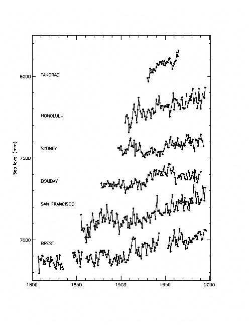
The PSMSL data set is studied by a wide range of researchers interested in climate change and its impacts, and has been the main source of our understanding that global sea level has risen at an average rate of 10-25 cm/century during the past century (Figure 1).
|
|
Figure 1: Long sea level records from each continent: Takoradi, Ghana (Africa), Honolulu (Pacific), Sydney (Australia), Bombay (Asia), San Francisco (USA) and Brest (Europe). Each record has been offset vertically for presentation purposes. Observed trends for the twentieth century are 3.1, 1.5, 0.8, 0.9, 2.0 and 1.3 mm/year respectively. The effect of postglacial rebound as simulated by the Peltier ICE-3G model is less than or of the order 0.5 mm/year at each site. |
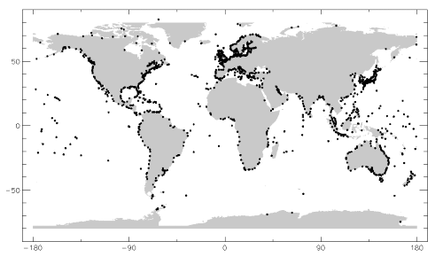
As of September 1998, the database of the PSMSL contains over 45,000 station-years of monthly and annual mean values of sea level from over 1800 tide gauge stations around the world received from almost 200 national authorities. On average, approximately 2000 station-years of data are entered into the database each year. Figure 2 shows the global coverage of the PSMSL data set.
In order to construct time series of sea level measurements at each station, the monthly and annual means have to be reduced to a common datum. This reduction is performed by the PSMSL making use of the tide gauge datum history provided by the supplying authority. To date, approximately two thirds of the stations in the PSMSL database have had their data adjusted in this way, forming the Revised Local Reference (or RLR) data set.
All PSMSL data are available via Anonymous FTP (File Transfer Protocol, a common method of moving files between two Internet sites). The Internet address is ‘bisag.nbi.ac.uk’ and PSMSL data can be found in the directory ‘/pub/psmsl’. This is the same address as used for FTP data sets by the British Oceanographic Data Centre and other groups at the Proudman Oceanographic Laboratory. The advantages of FTP in terms of providing data instantly, and at virtually zero cost, far outweigh any disadvantages.
|
|
Figure 2: Distribution of tide gauge stations within the PSMSL data set. |
Data can also be obtained via the PSMSL World Wide Web information pages at http://www.pol.ac.uk/psmsl/sea_level.html. This site provides information and contact names covering not only the PSMSL itself but also the Hawaii Sea Level Center, the two World Ocean Circulation Experiment Sea Level Centres, Proudman Oceanographic Laboratory’s South Atlantic sea level programme, and the Australian National Tidal Facility, together with links to the small number of national sea level data banks with data accessible via FTP or the web. PSMSL data are also available on CD ROM and subsets of data can be provided on an ad-hoc basis on floppy disk or as printouts by emailing psmsl@pol.ac.uk.
The Global Sea Level Observing System
The Global Sea Level Observing System (GLOSS) is a programme coordinated by the Intergovernmental Oceanographic Commission for the establishment of global and regional sea level networks. The main component of GLOSS is the Global Core Network of 287 stations around the world for long-term climate change and oceanographic sea level monitoring (Figure 3). One of the main purposes of this network is to improve the quantity and quality of sea level data delivered to the PSMSL.
|
|
Figure 3: The GLOSS Global Core Network. |
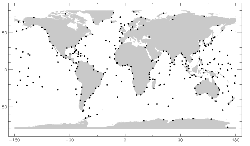
The status of GLOSS has improved each year during the past decade, and the Global Core Network can be considered to be over two-thirds operational, with concentration now focused on the remaining third which is primarily concerned with polar areas and remote ocean islands.
The GLOSS Station Handbook has been constructed in order to provide further information on each of the tide gauges in GLOSS. The Handbook is available as a CD ROM from the PSMSL, while station files can also be inspected from the GLOSS Handbook web version accessible via the above web address. The CD ROM version of the Handbook contains useful software and training materials which are not so far available via the web.
GLOSS has played a particularly important role in the provision of training courses and training materials to the worldwide community. During the past decade, the PSMSL has been involved in the organization of over 15 GLOSS training courses around the world. In 1998, a course was held at the University of Cape Town, and in 1999 at least one course will be held in South America. The British Council has also funded visiting scientists and technicians to train at the Proudman Oceanographic Laboratory.
GLOSS has a newsletter on the web called the GLOSS Bulletin (available from the Intergovernmental Oceanographic Commission). In addition, a newsletter called the Afro-America GLOSS News is published by the University of Sao Paulo on paper and on the web at http://www.mares.io.usp.br/, with most articles in Spanish or Portuguese.
The first proposals for GLOSS were developed during the mid-1980s by an Intergovernmental Oceanographic Commission Task Team of interested scientists led by David Pugh and Klaus Wyrtki. That resulted in the First GLOSS Implementation Plan.
More recently, the requirements for GLOSS, in particular with regard to the interactions with new technologies such as satellite radar altimetry, the Global Positioning System and absolute gravity, have been reassessed in the GLOSS Implementation Plan 1997. The Plan describes how it will be necessary to develop networks additional and complementary to the Global Core Network. These include:
- a GLOSS Long Term Trends set of gauge sites (some, but not all, of which are in the Global Core Network) for monitoring long- term trends and accelerations in global sea level, these will be priority sites for Global Positioning System receiver installations to monitor vertical land movements;
- a GLOSS altimeter calibration set, mostly islands, to provide an ongoing facility for mission intercalibrations; and,
- a GLOSS ocean circulation set, including in particular gauge pairs at straits and in polar area, complementing altimetric coverage of the open deep ocean.
In addition, an extensive set of regional networks will have to be developed, complementing and extending the “global” network where necessary.
The new Implementation Plan for GLOSS was accepted by the Intergovernmental Oceanographic Commission Assembly in July 1997 and copies can be obtained from either the authors of this article, or via the PSMSL web pages. GLOSS can also be considered as a component of the Intergovernmental Oceanographic Commission’s Global Ocean Observing System or GOOS (on the web at http://ioc.unesco.org/goos/).
The World Ocean Circulation Experiment
Recent years have seen major efforts to collect higher frequency (typically hourly) sea level data in order to provide an “in-situ” World Ocean Circulation Experiment (WOCE) data set, primarily for comparison to and validation of sea level data obtained from satellite radar altimetry. The designated WOCE tide gauges are mostly GLOSS island sites and pairs of gauges across straits and total about 100 stations. There are two World Ocean Circulation Experiment Sea Level Centres: one at the British Oceanographic Data Centre at the Proudman Oceanographic Laboratory alongside the PSMSL (the so-called “delayed mode centre”), and the other at the University of Hawaii Sea Level Center (the so-called “fast centre”). Each centre now has an extensive sea level data set which can be accessed via the PSMSL web pages.
Geocentric Coordinates of Tide Gauge Benchmarks
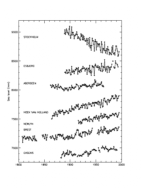
Vertical land movements are an extremely important signal in sea level records (Figure 4). Over the past few years, considerable developments have taken place with Global Positioning Systems and other advanced geodetic techniques for monitoring rates of vertical land movements.
|
|
Figure 4:. Long sea level records from selected sites north to south in western Europe. Each record has been offset vertically for presentation purposes. The apparent fall in sea level at Stockholm is owing to postglacial rebound of the land. The secular trends in stations further south are comparable to the global average. |
Arrangements are in place for the sea level community to work closely with the International Global Positioning System Service for Geodynamics, (another Federation of Astronomical and Geophysical Data Analysis Service), in order to provide time series of vertical land movements alongside the tide gauge sea level time series. This will thereby provide a decoupling of land and real sea level changes within the relative sea level tide gauge records.
In March 1997, a meeting on the use of Global Positioning Systems at tide gauge benchmarks was organized by the PSMSL and the Intergovernmental Global Positioning System Service for Geodynamics at the Jet Propulsion Laboratory in California. This workshop not only resulted in an important proceedings report but also laid the foundations for schemes for data processing and transfer, and for training in the use of Global Positioning Systems at gauge sites.
Publications and other activities
A wide range of publications are produced by the PSMSL and GLOSS, aside from those already referred to. The PSMSL FTP disk contains a list of technical publications relevant to the PSMSL and GLOSS. Possibly the most important are the 1990 and 1995 reports of the Intergovernmental Panel on Climate Change. Major conclusions have been that global sea level has indeed risen by approximately 10-25 cm during the past century and may rise by amounts several times larger during the next century.
The PSMSL provides a link to recent publications for third world scientists without access to extensive library facilities by undertaking keyword and other searches through the Proudman Oceanographic Laboratory’s library which holds probably the largest collection of sea level literature in the world.
Both the PSMSL and GLOSS attempt to stimulate the development of tide gauge networks within other countries at national and regional levels by means of conferences, working groups, and so on. At a technical level, the PSMSL provides software packages for tidal data analysis and quality control. Full participation is maintained with altimeter working groups in view of the importance of altimetry to sea level research. Indeed, the future development of the global tide gauge network is closely linked to the symbiosis with precise altimetry.
It can be seen that the PSMSL and GLOSS have active programmes for data acquisition and distribution, for training, for publicizing of sea level activities, and for scientific research. They will continue to serve the very broad scientific community of users and to develop in response to their requirements. Either author of this article would be pleased to discuss aspects of sea level research with anyone interested in the subject.
Further information
Philip Woodworth, Proudman Oceanographic Laboratory, Bidston Observatory, Birkenhead, Merseyside L43 7RA, UK. Fax: 44-151-6536269. Email: plw@pol.ac.uk. Web: http://www.pol.ac.uk/psmsl/sea_level.html.
Janice Trotte, GOOS Project Office, IOC, UNESCO, 1 rue Miollis, Paris 75732, Cedex 15, France. Email: j.trotte@unesco.org. Web: http://ioc.unesco.org/goos/.