![]()
El Niño 2002
Weak-to-moderate El Niño conditions prevailed during mid-2002, with forecasts suggesting these conditions would persist through to early 2003.
|
|
|
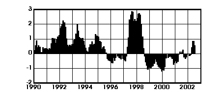
Multivariate ENSO Index: bimonthly data to June-July 2002. Compiled by Klaus Wolter, NOAA. Highest quality image - requires SVG Viewer |
During the first half of 2002, all oceanic and atmospheric indicators tracked the final breakdown of the prolonged La Niña event of recent years and the emergence of a new El Niño event in the tropical Pacific.
At present, the intensity and duration of the 2002/03 El Niño cannot be predicted with confidence, although it appears unlikely to rival the strength of the 1997/98 event.
The US National Oceanic and Atmospheric Administration (NOAA) is warning that the drier-than-average conditions experienced recently over Indonesia and eastern Australia may continue through to September 2002. Wetter-than-average conditions can be expected over southeastern South America. The Atlantic hurricane season may be more intense than usual.
The emergence of warming in the tropical Pacific should increase the chances of another record-breaking year as far as global temperature is concerned. The first half of 2002 has already proved particularly warm world-wide.
Further information
NOAA’s Climate Prediction Center produces a
monthly
forecast update. On
the Web: Seasonal climate forecasts – El Niño and Africa
and El Niño and the Southern Oscillation
list further links.