![]()
Natural disasters in Honduras
 |
Manuel Winograd reports on a project on vulnerability
and risk assessment of natural disasters in Honduras.
|
During the past thirty years, Central America has experienced economic losses due to natural events equivalent to two per cent of the region's GDP per year. The countries of Central America are affected every three or four years by drought and fires, and/or floods and landslides which have important effects on environmental, social and infrastructure vulnerability. As a result of climate change, extreme events such as storms, droughts, and floods are expected to increase even more in the future. After Hurricane Mitch in 1998, awareness of the high environmental impacts and socio-economic costs of natural events rose.
Vulnerability and risk assessment frameworks and methods need to be developed to improve the decision-making and planning processes in order to move from dealing with consequences to preventing the causes and mitigating the effects of natural disasters. The absence of methodology and data commonly results in the limited use of information and analysis for decision-making and planning. This results in more descriptive, anecdotal and non-systematic assessments of vulnerability and risk. In general, the institutions of Central America either do not have access to data and information or their databases are still unconsolidated, making it difficult to use and exchange information.
A vulnerability assessment framework concerns the physiology (that is, functions, dynamics, synergies) of changes on the environment and society. This vulnerability assessment framework aims to determine the risk of adverse outcomes for a specific unit or group faced with a variety of perturbations or stresses, identifying factors that reduce the capacity to respond and adapt to stresses.
The products of such a framework are analyses of specific effects as caused by multiple factors which can be used for strategic guidance for policy and decision-making. The framework and methods need to take into consideration the differential nature of risk and vulnerability because perturbations, stresses and impacts are distributed heterogeneously in space and time. Responses, options and strategies are, therefore, applied differently at regional, national and local levels. At the same time, uncertainty needs to be taken into account due to factors such as natural variability, our ignorance, and the unknowable and indeterminable nature of some phenomenon.
Thus, the main objective of this project is to provide guidance on how to assess vulnerability and risk in order to identify areas where prevention, reconstruction and mitigation options could have the greatest social, economic and environmental benefits. This objective is being fulfilled by providing decision makers at different levels with research on the means for assessing vulnerability and risk, and actions on how to reduce vulnerability and risk, as well as information to reduce uncertainty in decision making and policy making.
The effects of natural disasters on the economy, the society and the environment should be analysed not only in respect of their direct impacts but also in relation to the closely-linked indirect impacts. For example, the importance of infrastructure, such as road networks, in the development process, and the investment needed to develop and reconstruct it, is well known. Road networks allow access to markets, goods and services, the disruption of which can be considered an indirect effect of a natural disaster.
But it is not only the direct and indirect impacts of a natural disaster that should be analysed. The underlying causes, such as land use, agricultural practices, watershed management and urbanization, of both types of impacts should also be considered. For example, in hillside areas suffering from watershed deforestation and erosion, the likelihood and severity of landslides and mudslides and overflow of rivers in flat areas will increase, thus affecting basic infrastructure and urban areas as well devastating important agricultural areas.
What does this vulnerability and risk mean for a country like Honduras? The project took into account the function of the probability and magnitude of natural events such as Hurricane Mitch and the exposure and susceptibility of the environment.
We designed an environmental vulnerability index for Honduras, covering vulnerability to landslides as well as flooding by overflow and by poor soil drainage (Figure 1). Only the risk of landslides and flooding are highlighted in this index consistent with the impacts suffered in Honduras in the wake of Hurricane Mitch. The situation in the country is clearly alarming. The results show that more than 60 per cent of the territory has some type of risk from flooding or landslides, in particular the more populated and agricultural areas such as the axis of San Pedro Sula-Tegucigalpa-Choluteca.
|
|

|
Figure 1: Environmental vulnerability in Honduras. |
The next step was to overlap the environmental vulnerability index with population data in order to obtain a Combined Vulnerability Index that could help to identify the priority areas affected by natural events (Figure 2). This index took into account three main factors.
- The first is a population vulnerability index: total population by “village” at risk of flooding + total population by “village” at risk of landslides.
- The second is a social vulnerability index: total population by “village” by poverty levels at risk of flood + total population by “village” by poverty level at risk of landslides.
- The third is an infrastructure vulnerability index: roads type at risk of flood + roads type at risk of landslide + electricity lines type at risk of flood + electricity lines type at risk of landslides.
|
|

|
Figure 2: Priority areas according to the Combined Vulnerability Index. |
What did this analysis mean in terms of direct and indirect effects of Hurricane Mitch? The direct effects of Hurricane Mitch on the infrastructure were huge. This was particularly notable in the high impacts on the strategic road network of the San Pedro Sula-Tegucigalpa, Tegucigalpa-Choluteca, Pan-American Highway, as well as on the secondary road network, due to landslides, flooding and destroyed or damaged bridges.
Although the poor in Honduras would appear to be the most vulnerable population group when faced with natural disasters, when considering only the direct effects of Hurricane Mitch the poor do not necessarily seem to be any harder hit than other groups in society. However, if the indirect effects, that is, in the form of loss of accessibility, are taken into account the picture looks a bit different.
We proceeded to devise a map which showed areas that lost more than ten per cent of accessibility to markets together with the location of villages with severe and critical poverty levels.
The resulting mapping shows that there were some areas that only suffered indirectly. This was as a result of the damage to infrastructure, in particular the difficulty of access between population centres and rural areas which caused serious delays in the arrival of medical aid, food and seeds.
|
|

|
Figure 3: Reconstruction options. |
What did the vulnerability analysis mean in terms of prioritization for reconstruction? We considered the case of two potential reconstruction options that would help alleviate the impacts on Honduras’ poorer population (Figure 3). The first option is orientated toward reconstructing the strategic road axis in Honduras, grouping priority municipios by vulnerability, and recovering the accessibility between the most important cities, ports and productive areas. The second option is orientated toward reconstructing the road network that allows access to villages with high levels of poverty at the same time as isolating priority municipios by vulnerability.
|
|

|
Figure 4: Costs and benefits of the reconstruction options. |
We were then able to clearly show the costs and benefits of these two options (Figure 4). It was notable that in the first option not only is the cost lower but the number of poor people who benefit is higher than in the second option. Obviously, these two options are exploratory and not exclusive. The analysis was made with the goal of showing the importance of information for decision making, to explore planning strategies and to prioritize reconstruction options for the sectors most affected.
But the use of information for decision making and planning needs to go beyond simply monitoring the catastrophic effects of natural disasters on the economy, the society and the environment and planning reconstruction after the catastrophe has already occurred. What is needed is the possibility to go from short-term reaction to the immediate consequences on to the prevention of the direct and indirect causes in order to mitigate against future possible effects.
|
|

|
Figure 6: Land use and flooding impacts after Hurricane Mitch.. |
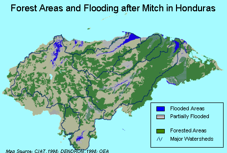
A first step toward this is to analyse the underlying causes of the situation caused by Hurricane Mitch, which does not only include abnormal amounts of rain during October 1998 (Figures 5 and 6). A combination of past problems, in fact, had an influence on the severity of the impacts of the hurricane. These problems include inappropriate land-use practices, high deforestation rates in the watersheds, and a lack of urban planning, early warning systems and investment in works to prevent and mitigate natural events.
|
|
|
Figure 6: Forest areas and flooding impacts after Hurricane Mitch.. |
Analysing patterns of impact and environmental change, it was shown that the flooding in the north, centre and south of the country could be due, in part, to the low forest coverage and land use changes in the watersheds. This land cover could exacerbate extremely erosive processes in the hillside areas resulting in a high risk of landslides and dammed rivers in the headwaters with inundation in the lower part of the river. This type of information on the underlying causes of the observed effects could be potentially crucial in helping to prioritize interventions such as identifying the financial aid and investment needed, the people and sectors that would benefit, and finally to plan mitigation and prevention actions.
In conclusion, we can say that the absence of planning in where a population is located, in land use and infrastructure together with the lack of application of any precautionary principles are the main causes of the increase in risk and vulnerability.
Generally, policies, strategies and actions are oriented toward solving consequences rather than preventing the causes. In consequence, “natural events” become “natural disasters.” It is easier to blame climate change or “natural events uncertainty” for the high impacts, consequences and effects of natural disasters rather than to plan, prevent and mitigate.
Taking into account the risk and vulnerability to natural events, the challenges confronting us are the need to explore and develop our adaptive capacity, take advantage of any emerging opportunities and learn to cope with the consequences.
Further information
Manuel Winograd, International Center for Tropical Agriculture
(CIAT), Apartado Aereo 6713, Cali, Colombia. Fax: + 57-2-4450073.
Email: m.winograd@cgiar.org.
Web: www.ciat.cgiar.org/indicators/index.htm.