Tiempo Climate Cyberlibrary
Too Much of a Good Thing
- Tiempo archive
- Complete issues
- Selected articles
- Cartoons
- Climate treaty
- Latest news
- Secretariat
- National reports
- IPCC
About the Cyberlibrary
The Tiempo Climate Cyberlibrary was developed by Mick Kelly and Sarah Granich on behalf of the Stockholm Environment Institute and the International Institute for Environment and Development, with sponsorship from the Swedish International Development Cooperation Agency.
While every effort is made to ensure that information on this site, and on other sites that are referenced here, is accurate, no liability for loss or damage resulting from use of this information can be accepted.
 |
Gwen Young (left), Barry Smit, Johanna Wandel and Humberto Zavala describe vulnerability to water resources under climate change in the semi-arid Elqui Valley, Chile. |
| Gwen Young is a research associate with the Global Environmental Change Group at the University of Guelph in Canada. Barry Smit is a geography professor and holder of the Canada research chair in global environmental change at the University of Guelph in Canada. Johanna Wandel is an assistant professor at the University of Waterloo in Canada where she specializes in the human dimensions of global change. Humberto Zavala is a civil engineer working in the private sector in Santiago, Chile, and a former faculty member at the Universidad de la Serena. | |
Livelihoods in dryland areas are inherently challenged by the demands of climate variability. Climate change is expected to have further implications for water resources in these areas. The Elqui River Basin, which stretches for approximately 130 kilometres from the Pacific Ocean to the High Andes in north-central Chile, is no exception. The basin is particularly sensitive as rainfall is very low, river discharge is highly variable and prolonged dry periods are common. Precipitation averages around 100 millimetres per year and the valley is greatly affected by intense precipitation events initiated by the El Niño-Southern Oscillation (ENSO) phenomenon.
The vulnerability of the Elqui community of Diaguitas to water and climate-related stresses was analysed by a multi-disciplinary team between 2006 and 2008. Data inputs for the study included participant observation, interviews, focus groups, climate and hydrological records and projections and administrative and historical documents. The conditions that affect livelihoods and contribute to vulnerabilities were documented. These included inter-related factors such as global climatic phenomena (especially ENSO), topography and landscape modification due to increased acreages of fruit crops related to international demand and national economic strategies.
This study demonstrates that, while moisture is desperately needed in an agriculturally productive dryland area, excessive moisture can sometimes be "too much of a good thing."
 |
|
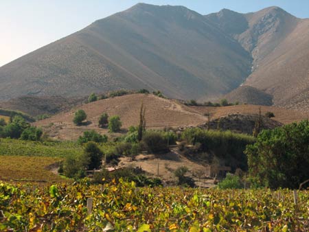
Cerro Mamalluca
© Gwen Young |
The study area
Diaguitas is a small rural community of 700 people, located 80 kilometres from La Serena, at an elevation of 687 metres above sea level. Diaguitas is adjacent to the Elqui River at the base of the precipitously steep hill, Cerro Mamalluca, which rises to 2219 metres. The valley has a thriving commercial agricultural industry, based on irrigation water drawn from the snow- and glacier-fed Elqui River. Major crops include table grapes, citrus and avocado for export. Intensive vineyards and plantations blanket the valley and hillsides surrounding the community. Large agricultural companies provide the main source of wage employment for the region. Prior to the arrival of these companies, residents relied on the productivity of their huertos (gardens or small farms). However, small farmers have difficulty generating income from small-scale crop production and often cannot refuse the salaries and high prices offered for their land or water rights. As a result, many residents have sold their land and water rights and taken up employment for wage labour. The community also includes a group of semi-nomadic goat herders who rely on rain-fed vegetation in the valley.
Most residents and businesses are either directly or indirectly dependent on water resources to sustain their livelihoods, through employment from agricultural companies, small-scale agricultural and livestock production, and for potable water. Due to this dependency, the community is sensitive to variations in climate and water regimes. Any extreme change in the nature of water resources or in the availability or use of water will have a corresponding effect on the community.
Coping with water variability
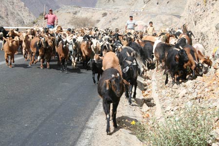
Members of the community experience the effects of water variability in different ways. For example, prolonged dry periods, typically coinciding with La Niña episodes, reduce natural vegetation growth leaving goats with insufficient food from their usual grazing areas. In the past, goat herders adapted to this by moving herds to other parts of the river valley and coastal areas, but this is becoming increasingly difficult because commercial agriculture is preventing access.
Intense and abundant rainfall events can trigger debris flows that cause significant damage to the community. Episodes of heavy rain (lluvias locas, crazy rains) tend to occur every few years, coinciding with El Niño conditions and following La Niña’s prolonged dry periods. During an El Niño year, annual rainfall can be two to three times higher than the annual mean. Community observations and instrumental records indicate an increase in extreme precipitation events. Community members feel that the rains have become much more intense in recent decades.
 |
|
Semi-nomadic goat herders in the Elqui Valley,
Chile
© Gwen Young |
In addition to precipitation events, topography and land use play a role in the debris flows affecting Diaguitas. Diaguitas’ location at the base of Cerro Mamalluca’s sparsely vegetated, dry, sandy slopes means that the community is in the direct path of the debris flows that occur when sediments are saturated. Although there are currently fewer goat herders than in the past, reduced access to the valley floor has contributed to more intensive grazing of the upper slopes. This has depleted the natural vegetation and reduced slope stability.
Two major debris flows in 1997 and 2004 inundated the community when lluvias locas occurred after prolonged dry periods. In 2004, more than 100 millimetres of rain fell in six hours triggering movement on the unstable slopes. The resulting debris flows destroyed homes, irrigation canals and crops. The flow caused the stream to swell, blocked roads and made parts of the community inaccessible. Residents were hospitalized with injuries and hypothermia and some were left homeless and were forced to relocate or replace their homes.
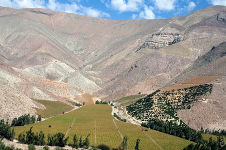
The risk of damaging debris flows is further exacerbated by landscape modification related to industrial agricultural development. The rapid boom in commercial agriculture, reflecting export-oriented national economic policies, influences slope instability by increasing planted areas. This removes natural vegetation and physically modifies the hillsides. Changes in land cover and land uses have also modified drainage patterns. Residents note that previously there were multiple quebradas (ephemeral creeks), which drained the slopes during periods of intense rainfall. With the modified landscape, there are fewer quebradas, increasing the force of the flow in those remaining and moving more debris. Residents indicated that when the land was covered by natural vegetation and the surface was unmodified by humans, the energy of the debris flows was dissipated and the damage was less.
 |
|
Vineyards and avocado plantations in Elqui Valley,
Chile
© Gwen Young |
Agricultural companies themselves are sensitive to water availability. The companies primarily rely on surface water from the Elqui River for irrigation. Surface water variations are managed through the adoption of technologies such as high-efficiency drip irrigation systems and water storage systems as well as the purchase of additional water rights. The continuing expansion of irrigated commercial agriculture in the valley has been facilitated by sustained river discharges, with some evidence of increases in supply since the 1970s. Ironically, this abundance may also be "too much of a good thing" as it could well indicate deficits to come. Climate change has already resulted in the depletion of glaciers throughout the Andes and many river systems experience increased flows as snow-lines become elevated and glaciers retreat, followed by depleted flows once the snow and ice sources are exhausted.
Conclusions
Diaguitas is already vulnerable to variations in the hydrological regime. Climate change, together with other forces, influences community exposure to potentially more frequent or intense storms and has implications for the long-term discharge of glacier-fed rivers such as the Elqui. The expanded agricultural industry and those employed in it are exposed to changes in the supply of irrigation water. As glaciers diminish with climate change and less runoff from snow is available in the summer months, seasonal competition for water in the agricultural sector will increase.
Adaptive strategies are already being employed to make the most efficient use of available water, maintain contingency reserves through additional water rights and store water. It is not clear whether these have the capacity to sustain the agricultural industry under future climate change and changes in river discharge. In addition, prolonged dry periods and an increase in the frequency and intensity of extreme rainfall events would likely trigger more debris flows, especially if land use changes continue to modify slope surfaces.
Since the most recent episode of lluvias locas in 2004, some adaptive measures have been attempted to reduce the damage associated with debris flows. The effectiveness of these adaptations, which include artificial channelling, barriers and emergency management, remains untested until the next period of slope instability.
Although Diaguitas is a dryland community, its residents and their livelihoods are generally well adapted to the historical moisture conditions. The climatic growing conditions and access to irrigation water through river discharge drew commercial agriculture to the Elqui Valley and provides the main employment for residents. However, significant reductions in the discharge of the Elqui River would likely exceed the adaptive capacity of commercial agricultural operations and residents. Similarly, increases in the frequency and intensity of extreme precipitation events, combined with land use changes, would likely increase the exposure to debris flows.
Acknowledgements
The Social Sciences and Humanities Research Council of Canada Multi-Collaborative Research Initiative on Institutional Adaptation to Climate Change (IACC) funded this research. The work benefited from the insights of the entire IACC team, in particular, Polo Diaz, Sonia Salas, Elizabeth Jiminez, Roxana Espinoza, Melitta Fiebig, Jorge Cepeda and Hector Luis Morales.
Disclaimer
The views expressed in this article are the authors’ personal views and do not represent those of their respective countries or the organizations supporting the research.
Further information
Barry Smit, University of Guelph, Guelph, Ontario, Canada N1G2W1. Fax: +1-519-8370811. Email: bsmit@uoguelph.ca. Email: gwendolynneyoung@gmail.com. Email: jwandel@uwaterloo.ca. Email: humberto.zavala@poch.cl. Web: www.parc.ca/mcri/.
Bright Ideas

General Electric plans to cut solar installation costs by half

Project 90 by 2030 supports South African school children and managers reduce their carbon footprint through its Club programme

Bath & North East Somerset Council in the United Kingdom has installed smart LED carriageway lighting that automatically adjusts to light and traffic levels

The United States National Oceanic and Atmospheric Administration and the American Public Gardens Association are mounting an educational exhibit at Longwood Gardens showing the link between temperature and planting zones

The energy-efficient Crowne Plaza Copenhagen Towers hotel is powered by renewable and sustainable sources, including integrated solar photovoltaics and guest-powered bicycles
El Hierro, one of the Canary Islands, plans to generate 80 per cent of its energy from renewable sources

The green roof on the Remarkables Primary School in New Zealand reduces stormwater runoff, provides insulation and doubles as an outdoor classroom

The Weather Info for All project aims to roll out up to five thousand automatic weather observation stations throughout Africa

SolSource turns its own waste heat into electricity or stores it in thermal fabrics, harnessing the sun's energy for cooking and electricity for low-income families

The Wave House uses vegetation for its architectural and environmental qualities, and especially in terms of thermal insulation

The Mbale compost-processing plant in Uganda produces cheaper fertilizer and reduces greenhouse gas emissions

At Casa Grande, Frito-Lay has reduced energy consumption by nearly a fifth since 2006 by, amongst other things, installing a heat recovery system to preheat cooking oil
Updated: May 15th 2015