Tiempo Climate Cyberlibrary
Research Laboratory
- Tiempo archive
- Complete issues
- Selected articles
- Cartoons
- Climate treaty
- Latest news
- Secretariat
- National reports
- IPCC
About the Cyberlibrary
The Tiempo Climate Cyberlibrary was developed by Mick Kelly and Sarah Granich on behalf of the Stockholm Environment Institute and the International Institute for Environment and Development, with sponsorship from the Swedish International Development Cooperation Agency.
While every effort is made to ensure that information on this site, and on other sites that are referenced here, is accurate, no liability for loss or damage resulting from use of this information can be accepted.
|
Climate analysis tools — selected resources in the Tiempo Climate Cyberlibrary and on the web
|
In the Cyberlibrary
Engaging Local Society in the Research Process
Luong Quang Huy describes a participatory research approach designed to empower local communities in adapting to socio-economic trends and climate change. Published September 2010
Modelling Adaptation?
Ian Burton calls for adaptation modelling to inform a new authoritative review quantifying economy-wide adaptation benefits. Published February 2007
On the Web
Advanced Regional Prediction System
The aim of the Center for Analysis and Predictions of Storms (CAPS) in the USA is to demonstrate the practicability of storm-scale numerical weather prediction with an emphasis on deep convective storms. CAPS is making available a prototype regional forecast system appropriate for operational and research applications.
Assessments of Impacts and Adaptations to Climate Change in Multiple Regions and Sectors
The website synthesizes information on the sectors, systems, and groups studied, methods utilized, and key results of the 24 AIACC (Assessments of Impacts and Adaptations to Climate Change in Multiple Regions and Sectors) projects in the Americas, Africa and Asia.
Atmosphere-Ocean Model
Provides access to the computer programme enabling model simulations as well as further data and information files related to climate prediction.
Canadian Climate Change Scenarios Network
The Canadian Climate Change Scenarios Network consists of separate nodes, representing different regions of Canada and with their own research specialty. Each node is hosted in partnership with our university collaborators and the Adaptation and Impacts Research Section of Environment Canada.
CARBOAFRICA
The aim of the CARBOAFRICA network is to improve the quantification, understanding and prediction of the carbon cycle, and other greenhouse gas budgets, in Sub-Saharan Africa.
Carbon Capture and Sequestration Technologies
The Carbon Capture and Sequestration Technologies Program at the Massachusetts Institute of Technology conducts research into technologies to capture, utilize, and store carbon dioxide from large stationary sources.
Climateprediction.net
Climateprediction.net is the largest experiment to try and produce a forecast of the climate in the 21st century. You can download a climate model from this website that will run automatically as a background process on your computer. As the model runs, you can watch the weather patterns evolve. The results are returned to this site where you will be able to see a summary.
Coastal Typology Development
The global coastal zone typology enables the grouping of the world's coastal zone into clusters of discrete units based on both natural and socio-economic features and processes. The typology dataset can be downloaded.
Coordinated Enhanced Observing Period
Provides a foundation for the World Climate Research Program in cooperation with WMO to establish an integrated global observing system for the water cycle. Access to data sets, schedule of activities and publications and related links.
Data Access Tools
Acess to climate and climate-related data from the National Climate Data Center in the United States.
DECC 2050 Calculator Tool
The 2050 Calculator Tool from the UK Department of Energy and Climate Change aims to help policymakers, the energy industry and the public understand how to move to a secure, low-carbon energy system over the period to 2050.
Earth System Research Laboratory
NOAA's Earth System Research Laboratory was formed to pursue a broad and comprehensive understanding of the Earth system. It has four main themes: understanding atmospheric mechanisms that drive the Earth's climate; assuring the continuing health and restoration of atmospheric resources; improving predictions through expanded climate and weather products; and advancing national research capabilities.
Ecosystem Informatics
Ecosystem Informatics has been developed to provide data, information and ecological modelling for forecasting changes in Earth's life support systems. The programme has been developed by NOAA's Satellite and Information Services, the Geophysical Data Center, and the University of Colorado's Cooperative Institute for Research in the Environmental Sciences.
Environmental Protection Agency National Library Network
The National Library Network intends to improve access to information for decision making and environmental awareness held at the various EPA centres, laboratories and research institutions in the United States.
Exchange for Local Observations and Knowledge of the Arctic
The goal of Exchange for Local Observations and Knowledge of the Arctic (ELOKA) is to facilitate the collection, preservation, exchange and use of Local and Traditional Knowledge research and community-based monitoring of the Arctic by providing data management and user support and to foster collaboration between local and international researchers.
FUND
The Climate Framework for Uncertainty, Negotiation and Distribution (FUND) is a so-called integrated assessment model of climate change. FUND was originally set-up to study the role of international capital transfers in climate policy, but it soon evolved into a test-bed for studying impacts of climate change in a dynamic context, and it is now often used to perform cost-benefit and cost-effectiveness analyses of greenhouse gas emission reduction policies, to study equity of climate change and climate policy, and to support game-theoretic investigations into international environmental agreements.
Global Carbon Project
The aim of the Global Carbon Project is to develop a complete picture of the global carbon cycle, including both its biophysical and human dimensions together with the interactions and feedbacks between them. It publishes an annual update of carbon budget data.
Global Mountain Biodiversity Assessment
Supporting a global network on mountain biodiversity research, the site details planned activities including database development and future workshops.
Globalis - interactive world map
Globalis is an interactive world atlas that can be used to plot country-level data on environment and development.
GLOBCOVER
The objective of GLOBCOVER is to produce a global land-cover map for the year 2005 using fine resolution (300m) satellite data.
Grants and other funding opportunities
SciDev Net maintains an up-to-date list of funding opportunities in the area of science and development.
Grid Analysis and Display Software (GrADS)
GrADS is an interactive display tool used for the analysis and display of earth sciences data.
Historical hurricane tracks
An interactive mapping tool to search and display historical storm tracks and related data through entering local or regional coordinates. Access available to website for active storm information.
Impacts of Climate Change on World Food Supply
The results of a study of climate impacts on crop yields are available at this site and can be viewed through an interactive query interface.
Integrated Assessment Of Climate Change: Model Visualization and Analysis
Model Visualization and Analysis for Climate Change Integrated Assessment supports the community of researchers and policy analysts involved in modeling and assessing the impacts and policy implications of climate and global environmental change. The website provides access to data from climate change research, as well as citations and information related to these efforts. It also provides access to geospatial data relevant to climate change.
Intergovernmental Oceanographic Commission
The Intergovernmental Oceanographic Commission coordinates international scientific research on the world's oceans. The site contains details of current programmes, news and access to scientific expertise.
Intergovernmental Science-Policy Platform on Biodiversity and Ecosystem Services
The Intergovernmental Science-Policy Platform on Biodiversity and Ecosystem Services provides a bridge between science and policy making.
International Research Institute for Climate and Society
The International Research Institute for Climate and Society uses a science-based approach to enhance society's capability to understand, anticipate and manage the impacts of climate in order to improve human welfare and the environment, especially in developing countries.
International Research Institute for Climate and Society
The International Research Institute for Climate and Society uses a science-based approach to enhance society's capability to understand, anticipate and manage the impacts of climate in order to improve human welfare and the environment, especially in developing countries. Website resources include educational material, data and forecasts, research tools and publications.
International Research Institute for Climate Prediction
The core mission of the International Research Institute for Climate Prediction (IRI), a unit of the Earth Institute at Columbia University, is to enhance society's ability to understand, anticipate and manage the impacts of seasonal climate fluctuations, especially in developing countries. The IRI's current research locations include Latin America, Sub-Saharan Africa, and South and South East Asia.
MATerials Technologies for greenhouse gas Emission Reduction (MATTER) project
The MATTER project is developing an integrated energy and materials system for western Europe. Model input and output and well as information about the project can be viewed on this site.
Millennium Ecosystem Assessment
The Millennium Ecosystem Assessment is an international work programme designed to meet the needs of decision makers and the public for scientific information concerning the consequences of ecosystem change for human well-being and options for responding to those changes.
NASA GISS surface temperature analysis
The NASA Goddard Institute of Space Studies surface temperature analysis provides a measure of the changing global surface temperature for the period since 1880.
NatCarb
The NatCarb website presents background information and interactive maps on the process of storing carbon dioxide.
National Carbon Calculator
The Guardian's National Carbon Calculator allows you to set United Kingdom policy on energy, transport and other sectors and measure the carbon emissions generated.
NOAA Paleoclimatology Program
The Paleoclimatology Program's goal is to assist the world share data, software and information on past long-term climate variability.
Octave
GNU Octave is a high-level language, primarily intended for numerical computations, that is mostly compatible with Matlab. It is available at no charge.
Office of Scientific and Technical Information. Department of Energy (DOE)
The Office of Scientific and Technical Information manages access to information resulting from research and development programmes mounted by the United States DOE, including global change research.
Online Access to Research in the Environment
Online Access to Research in the Environment, an international public-private consortium coordinated by the United Nations Environment Programme, Yale University, and leading science and technology publishers, enables developing countries to gain free access to one of the world's largest collections of environmental science literature.
Pacific Climate Impacts Consortium
The Pacific Climate Impacts Consortium is a regional climate service centre at the University of Victoria that provides practical information on the physical impacts of climate variability and change in the Pacific and Yukon region.
Pacific Tropical Cyclone Data Portal
The aim of the Pacific Tropical Cyclone Data Portal is to improve knowledge of past tropical cyclone activity in the Pacific Islands and East Timor. The portal can be used to plot tracks of cyclones in the South Pacific between 1969 and 2010.
R-Project for Statistical Computing
R is free software, providing a wide variety of statistical (linear and nonlinear modelling, classical statistical tests, time-series analysis, classification, clustering, and so on) and graphical techniques relevant to climate research.
Rainman Streamflow
Rainman contains rainfall data for 3800 locations and streamflow records for nearly 400 locations in Australia and the ability to analyze these data and predict future variability, based on the ENSO phenomenon and sea surface temperatures.
Space Physics Interactive Data Resource (SPIDR)
A comprehensive collection of data made available by the Solar-Terrestrial Physics Division of the US National Geophysical Data Center. Data can be browsed and visualized on-line.
Twin2Go
The aim of Twin2Go is to draw policy-relevant research results on issues around adaptive water governance in the context of climate change and to make them transferable to other basins.
UK Climate Impacts Programme
The UK Climate Impacts Programme helps organizations to adapt to inevitable climate change. Site includes a range of tools.
UK Climate Projections
Access to climate scenarios for the United Kingdom.
Weather Processor
The Weather Processor, developed by Purdue University, is a general purpose weather visualization tool for current, forecast and archived meteorological data.
Weather Shop
A range of weather instrumentation and software for amateurs and professionals can be found at the Weather Shop.
Autogenerated: 15 May 2015
Bright Ideas
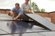
General Electric plans to cut solar installation costs by half

Project 90 by 2030 supports South African school children and managers reduce their carbon footprint through its Club programme
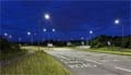
Bath & North East Somerset Council in the United Kingdom has installed smart LED carriageway lighting that automatically adjusts to light and traffic levels
The United States National Oceanic and Atmospheric Administration and the American Public Gardens Association are mounting an educational exhibit at Longwood Gardens showing the link between temperature and planting zones

The energy-efficient Crowne Plaza Copenhagen Towers hotel is powered by renewable and sustainable sources, including integrated solar photovoltaics and guest-powered bicycles
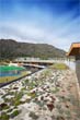
El Hierro, one of the Canary Islands, plans to generate 80 per cent of its energy from renewable sources
The green roof on the Remarkables Primary School in New Zealand reduces stormwater runoff, provides insulation and doubles as an outdoor classroom

The Weather Info for All project aims to roll out up to five thousand automatic weather observation stations throughout Africa
SolSource turns its own waste heat into electricity or stores it in thermal fabrics, harnessing the sun's energy for cooking and electricity for low-income families

The Wave House uses vegetation for its architectural and environmental qualities, and especially in terms of thermal insulation

The Mbale compost-processing plant in Uganda produces cheaper fertilizer and reduces greenhouse gas emissions

At Casa Grande, Frito-Lay has reduced energy consumption by nearly a fifth since 2006 by, amongst other things, installing a heat recovery system to preheat cooking oil
Updated: May 15th 2015